Caswell in Aroostook County was organized on April 14, 1879, as Pleasant Ridge Plantation. In 1870 the population was 67; in 1880, it was 326! (Its population in 2000.) Caswell was incorporated as a town on July 16, 1986, including in its boundary the former Granville Plantation. According to George Varney* in 1886,
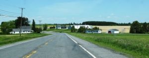
The surface of the township is very level, with a few small ponds. The soil is a deep reddish loam. Wheat, buckwheat, oats and potatoes yield swell. Maple, birch, spruce and fir constitute the bulk of the forests. The Plantation has a saw-mill manufacturing 2,000 feet of long lumber a day. [Possibly accounting for the leap in population during the previous decade.]
Just north of Limestone and Loring Air Force Base, on the northeastern edge of Maine, this rural community lost more than half its population between 1970 and 2000, due in part to the closing of the airbase. — Maine, an Encyclopedia
*Varney, George J. A Gazetteer of the State of Maine. 1886. p. 168-169